Kettleshulme, Saltersford and the Jenkin Chapel - by Charlie Hulme
It was a fine autumn day in October 2008 when Joanna and I set out to cycle from Disley station (180 metres above the sea) to cycle via Lyme Handley and Kettleshulme, aiming for the legendary point known as Pym Chair, 461 metres above sea level in the highest part of Cheshire, and beyond to the Jenkin Chapel in Saltersford.
Our route lay through the stamping ground of my Hill family ancestors (see my George Hill page) so I thought I would put a picture report here as an excuse to tell some more family history.
Special thanks to Moira Morris for setting me right on some points of the Boothby story.
Links:
Jenkin Chapel (Grade II* listed) described by British Listed Buildings
Jenkin Chapel on the Goyt Valley website
The 'Triple-M Register' has an archive article (PDF) about the Jenkin Chapel Test Hill from a 1935 MG Magazine.
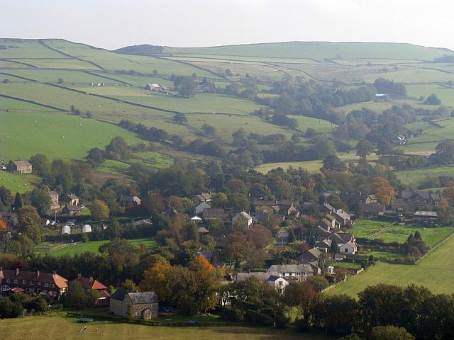
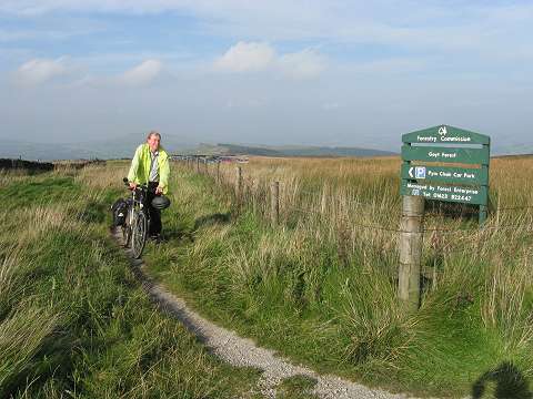
Above: the vista of the village of Kettleshulme from a lay-by thoughtfully provided on the Lyme Handley road, point (1) on the map below.
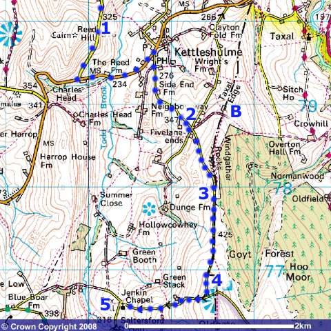
The map shows our route. (Image produced from the Ordnance Survey Get-a-map service. Image reproduced with kind permission of Ordnance Survey and Ordnance Survey of Northern Ireland. )
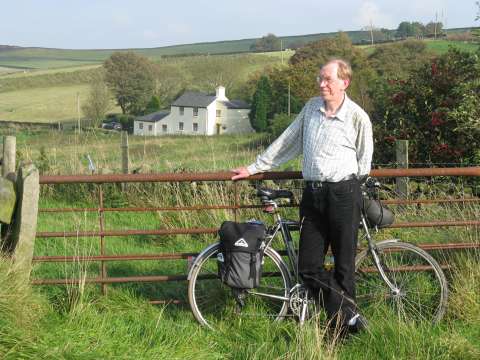
The scattered hamlet of 'Five Lane Ends' was at one time the heart of 'Hill country.' Behind me in this view taken at Point (2) on the map is Chapel House, once called 'old chapel house' and now a well-kept residence. At one time it was two homes, which in 1861 were occupied by three generations of my family. On a clear day, from this point you can pick out the towers of Manchester, about 25 km away.
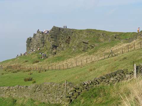
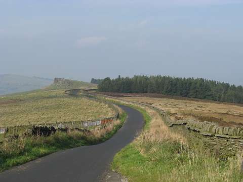
Turning right at Five Lane Ends, and climbing steadily, we pass the landmark gritstone outcrop known as Windgather Rocks, point (3), a favourite training ground for novice mountaineers, as can be seen.
Pym Chair (4) the highest point of our ride. I'm posing on the footpath from Windgather: we actually arrived by the road which is just off the picture to the left. I have never actually lived high up in these hills, my own childhood home being down in the valley at Whaley Bridge, but somehow I feel very much at home among them.
Looking back towards Windgather Rocks. 'Pym Chair' refers to a supposedly chair-shaped outcrop, which seems to have eroded in recent times, somewhere behind the camera, Pym was a either a preacher or a highwayman, or was he? Pick your own legend! (There is another Pym Chair on Kinder Scout: maybe it is just an old dialect word.) On foot, one can continue beyond Pym Chair on a path which leads to the summit of Shining Tor, the highest point in Cheshire (559 metres); cyclists and motor vehicles can turn left to descend into Derbyshire and Errwood reservoir, or turn right for a very steep descent into the scattered community of Saltersford. These roads were once used to carry salt by pack-horse from Cheshire to other parts of the country.
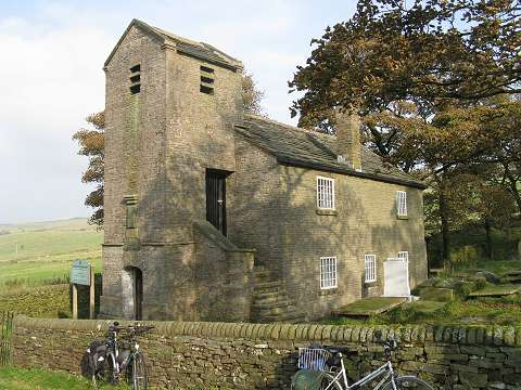
Jenkin Chapel, point (5) on the map, was built by and for the local farming community, in the local farmhouse style, to give them a place to worship without the long and hilly walk to the nearest church at Taxal. It still hosts a service once a month. Originally dedicated to St John the Baptist, it was later revised to St John the Evangelist.
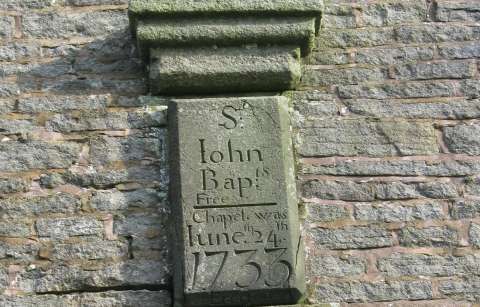
The stone marking the date of the Chapel's completion in 1733. In its early days, it was a 'Free Chapel', only becoming a Parish Church in 1864 to serve Kettleshulme, which had previously been part of Prestbury parish.
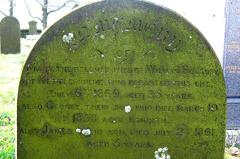
In the graveyard, at the farthest end, lies the grave of Mary Boothby, my great-great-grandmother, 'the beloved wife of William Boothby, who departed this life, July 6th, 1869, aged 35 years.'
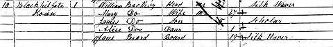
In 1861, as the above census snippet shows, she had lived at Black Hill Gate House - (B) on the map - part of Black Hill Gate farm, or Blackhill Gate, with her husband, my great-great-grandfather William Boothby, a silk weaver. Mary appears to have been the widow of silk weaver John Beard, who was the head of household at Black Hill Gate in 1851. According to the marriage cerrificate William was a widower at age 22 when he married Mary, so she was his second wife.
Their elder son George, who died on March 19th 1858 aged 1 month, so never appeared on any census. His brother James, who is shown on the census record as a 'scholar' aged five, died on July 2nd 1861, just a few weeks after being recorded by the census enumerator, leaving Alice, born in 1860, who later married George Hill and became my great-grandmother. Jane Beard, age 19, also a silk weaver, was living with them. They were weaving in the house using hand looms; family legend says someone from the family had to walk to Macclesfield each week carrying the finished cloth, returning with a new supply of thread.
Ten years later, in the 1871 census, William Boothby, aged 37, now shown as a 'Quarry Man', is recorded living at Ely Fold, Kettleshulme, with daughter Alice, now aged 10, and also son John (aged 7), son William (aged 4) and daughter Mary (aged 2.) Mary must have died not long after her daughter Mary was born.
William married again, to another Mary: The very first entry in the marriage register of Whaley Bridge Wesleyan Chapel (opened on 17 September 1868) as transcribed on the marvellous www.disley.net website, reads:
On 11 Nov 1869 William
Boothby, 36, Widower, Quarryman of Kettleshulme, son of
George Boothby, Cotton Operative, married May Trueman, 40,
Spinster, House Keeper of Bugsworth, daughter of John
Trueman, Farmer. In the presence of William Ashby
and Sarah Ashby.
Bugsworth, now called Buxworth, is a village in Derbyshire, about 5 km away from Kettleshulme on the opposite side of Whaley Bridge. The 1871 Census shows his wife as Mary, which is probably correct. Elsewhere we read that 'this being the first Marriage Solemnized in this Chapel the happy pair were presented with a handsomely Bound Bible and hymn Book.'
Black Hill Gate farmhouse, which had been shown as 'unoccupied' in 1871, was a farm again in 1881, and Alice Boothby was living there as a servant when she met and married George Hill. The name was spelled 'Blacklegate' by the enumerator, Joseph Wood, and now included in the Taxal census rather than Kettleshulme - it lay right on the border line between Cheshire and Derbyshire, as the map above shows. William was living at Coal Hurst, Kettleshulme and his
occupation is recorded as a farmer of 32 acres.
Ten years later, in 1891, we find William, his son William, and William (senior's) third wife Mary living at Green Head, a small farmstead in Kettleshulme on the high road towards Whaley Bridge. William senior is listed as 'Farmer and Quarryman.' One imagines he was using the smallholding to supplement his income from the quarry. William junior is a 'Collier' - probably working at one of the mines then still working in Whaley Bridge.
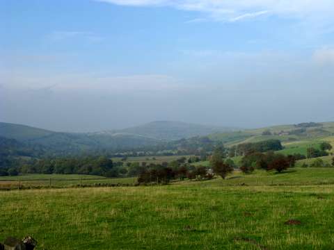
A final view, from Jenkin Chapel, looking towards Whaley Bridge. The hill in the centre is Eccles Pike, which is between Whaley Bridge and Chapel-en-le-Frith.
After leaving Jenkin Chapel, we decided to head for home via the route which was famous in the 1930s as the 'Jenkins Chapel test hill.' Motorcycles, and MG cars, would be time-trialled up its muddy gradient as a form of sport; the road - now labelled by the Ordnance Survey as 'other routes open to the public' - leaves Jenkin Chapel downhill to a stream crossing, and then climbs back up the other side at a fearsome gradient which is the actual 'test hill'. The first part of the climb is now metalled with cobbles; this appears to be a recent development connected with the conversion of an old farm building into a home. Once past this house, there is now a locked gate preventing motor vehicle access and a sign banning motorcycles; and the climb continues up what has become a stream bed, flowing with water and mud on this day as there had been considerable rainfall. We managed to push the bikes to the top, but never again!
Written by Charlie Hulme, last update October 2017.
Comments welcome: charlie@davenportstation.org.uk